Ref: https://www.ccc.govt.nz/the-council/haveyoursay/show/528
Introduction
“Spokes” – Spokes Canterbury (http://www.spokes.org.nz/) – is a local cycling advocacy group with approximately 1,200 followers and is affiliated with the national Cycling Action Network (CAN – https://can.org.nz/). Spokes is dedicated to including cycling as an everyday form of transport in the greater Christchurch and Canterbury areas.
We would like the opportunity to appear at any public hearing held to consider submissions on this project or any opportunity to develop ideas in this submission further.
Northcote Road and Lydia Street Transport Improvements
Spokes supports the desire to have safer access for pedestrians and cyclists around schools but feels that this proposal to provide increased safety for students at the new Marian College site is too limited in scope and will come at the expense of safety for students of St Bede’s College, Papanui High and other cyclists using Northcote Road. We would like to see a more holistic view of the area, including the creation of a separated two-way cycle connection between Queen Elizabeth II (QEII) Drive and the Northern Line.
Comments on the Current Proposal
It has been difficult to comment on this proposal without knowing what is happening at the proposed PAKnSAVE site. On Google Maps Lydia Street continues to the Main North Road however both the road and pedestrian access are currently fenced off. It is unclear if cars, cyclists or pedestrians will be able to go through this area yet it presents some other alternatives to the one proposed. It is hard to determine the likely traffic flows on Lydia Street without this information.
Spokes:
- Agrees with the speed reduction to 30 Km/hr and removal of parking on Lydia Street
- Agrees with left out only from Lydia Street to Northcote Road
- Agrees with shared path on Lydia Street (it would be preferrable if this went right through to Main North Road).
- Agrees with crossing on Lydia Street, however this should be designed to clearly be a combined cyclist/pedestrian crossing (like Ilam Road) with “Give way to Cyclists and Pedestrians” signs and with appropriate speed humps. The pedestrian refuge indicates that cars have priority over pedestrians when for safety of the most vulnerable, ie cyclists and pedestrians, it should be the opposite.
In addition:
- The traffic lights between 35 and 46 Northcote Road should include separate cycle phasing in addition to pedestrian phasing to allow cyclists, pedestrians and vehicles to use the crossing independently. Spokes notes that this may need some additional width and bars.
- Limit access to Lydia Street from Northcote Road to be left-in only, removing the need for a right hand turn on Northcote Road. This will make it safer for cyclists on Northcote Road by leaving more room between cyclists and trucks.
- The bus stop outside 39 Northcote Rd needs further discussion as it will need to be re-designed to fit Spokes’ proposed separated cycleway (as detailed immediately below).
Create a two-way separated cycleway (700m) on the southern side of Northcote Road
The proposed changes on Northcote Road will impact on the much-needed 700m connection between the cycleway on Queen Elizabeth II Drive and the Northern Line at Vagues Road. Creating a two-way separated cycleway will improve safety and access for Marian College, St Bede’s College and Papanui High School students as well as providing safer access to the Graham Condon Recreation Centre and Papanui Domain.
This small unprotected section is used regularly by cyclists and is not very safe. Traffic tends to be heavy on Northcote Road with a large number of trucks. The painted cycle lanes are narrow, particularly the section between Main North Road and Lydia Street on the south side, and the whole section on the north side. Less confident cyclists are choosing to cycle on the footpath. (And of course, we do not know how many do and will choose not to cycle this route at all because of the perceived and real danger).
The current suggested changes will make this section of Northcote Road worse for cyclists by pushing the east bound traffic further north (left) to create a right-turning lane into Lydia Street. The number of large trucks on Northcote Road makes this particularly scary.
The vision of the cycleways is to create a safe network for those aged 8 to 80 years. This is an opportunity to create a solution that will benefit a much wider group by:
- Creating a two-way separated cycleway on the southern side of Northcote Road from Main North Road to Vagues Road to complete the 700m gap between the two existing cycleways:
- QEII Drive (which connects to the Northern Arterial as well as New Brighton) and
- Northern Line (which runs alongside the main trunk railway line from Tuckers Rd to the north and connects to Hagley Park to the south).
- Changing the lights at Main North Road, QEII Drive and Northcote Road to have a combined pedestrian and cycle sequence both from St. Bede’s College across QEII Drive and across Main North Road, and a properly designed approach to the lights for cyclists from the QEII cycleway
- Change Lydia Street to be left in and left out only, which removes the need for a right turn and allows the traffic to move better.
Doing the roadworks on Northcote Road once will be cheaper and be less disruptive, particularly as the currently proposed changes would need to be reworked in any case at some stage.
Northcote Road is used by a significant number of cyclists. In a quick survey on Monday 1 August from 2.45pm to 3.15pm (30 min) on the south side of Northcote Road heading west there were 22 cyclists, one manual scooter, and four motorbikes using the current painted bike lane. On the southern footpath there were three cyclists (two going east, one going west) and four pedestrians. During this survey over half of the traffic heading west were St Bede’s College students.
There were ten cyclists on the north side of Northcote Road heading east from 2.55pm to 3.15pm (20 min) in the painted cycle lane although some may have been missed due to the heavy traffic and large vehicles obstructing the view.
It would be interesting to do a count by gender of cyclists on Northcote Road as female cyclists tend to be more risk adverse. From memory there was only one female cyclist during this period. Encouraging more girls at Marian College to cycle will require the higher level of safety and confidence that comes with separated cycleways. Safety must be acceptable to both the school-aged cyclists and their parents. Spokes asks that CCC:
- Install bike counters ASAP in this area to enable the recording and measurement of before-and-after cyclist counts.
- Plan for surveying of cyclist counts by gender, and preferably subjective information / anecdote, at the end of the works.
Increasing active transport, both cycling and walking, fits with the Christchurch City climate and transport goals.
7 August 2022
Submitted on behalf of Spokes Canterbury
Anne Scott, Submissions Convenor
submissions@spokes.org.nz
Cell: 027 450 4216
8/8/22 1315 Emailed to Sam Sharland, Engagement Advisor, samantha.sharland@ccc.govt.nz
by Chris Abbott on behalf of Anne Scott.
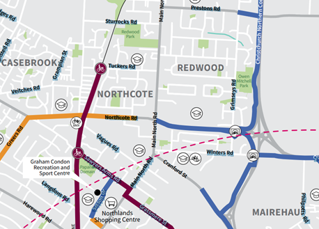
Appendix 1 Major Cycle Routes near Northcote Rd
(NB In the emailed submission the screenshot from Google Maps was included here.
On this, the Spokes website submissions page, the map is the feature image at the top of the page).
Ref: https://www.ccc.govt.nz/assets/Documents/Transport/Cycling/map/Bike-Easy-Guide-and-Map.pdf
NB1 The gap between the purple Northern Line major cycle route (MCR) and the blue dedicated cycle paths to the east (right). The roads coloured yellow are serviced by on-road bike lanes, not separated MCRs.
NB2 The dashed arc represents a distance of 5km from the “city centre” ie Christchurch Anglican Cathedral in Cathedral Square.